
English| EUR
Suggested for you
More currencies
Choose a language
The Tamarind Falls hike follows an unmarked network of footpaths, scramble routes and river crossings that link seven distinct waterfall tiers across private sugarcane land and forested ravines. Without posted trail markers or fixed entry gates, navigation relies on terrain reading, local waypoint knowledge and a working sense of the ridge-to-ravine descent pattern that structures the entire route.
Quick answer
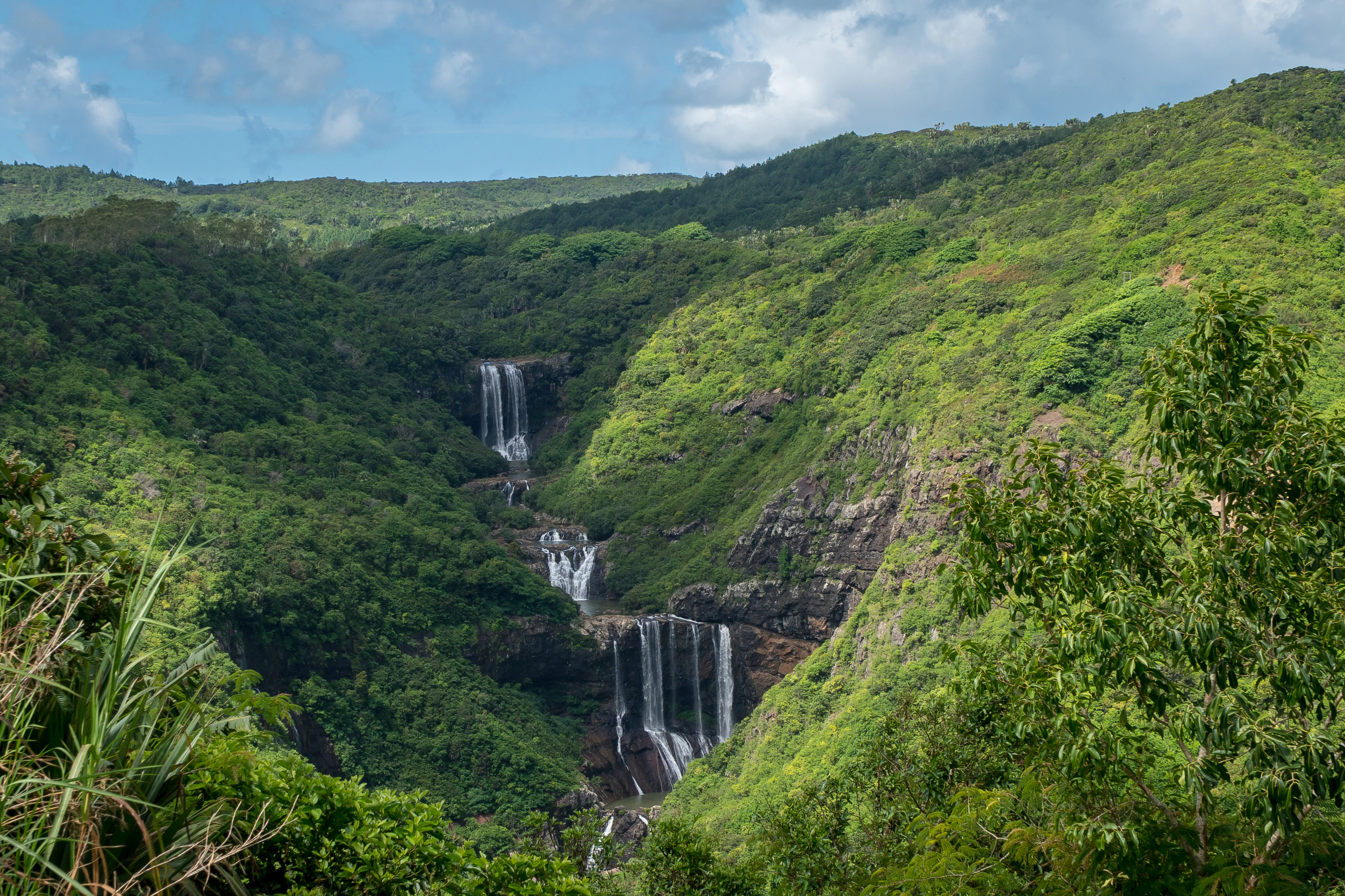
A tamarind falls hike map shows the descent from Henrietta Branch Road through seven cascading waterfall tiers, each separated by scramble sections, river crossings and unmarked trail junctions. The main route descends roughly two kilometers northwest into the ravine, with side paths leading to individual cascade viewpoints. Most hikers turn back after the third or fourth tier; reaching all seven requires rope-assisted descents and adds significant return climb time.
The Seven Cascades occupy a stepped basalt gorge where the Tamarin River drops through successive rock shelves between agricultural plateau and coastal lowland. Each waterfall tier sits at a different elevation, and the trail system connecting them evolved informally over decades—packed dirt paths worn by guides and repeat visitors rather than engineered routes. No official trailhead exists. Hikers enter via dirt tracks branching from Henrietta Branch Road, cross sugarcane field margins, then follow the sound of water downslope until the first cascade pool appears. The tamarind falls hike map typically divides the descent into three navigational zones. The upper section—tiers one through three—follows a relatively clear footpath with moderate gradient and visible boot-worn dirt. Junctions are unmarked but foot traffic keeps the main line apparent. The middle section—tiers four and five—requires hands-on scrambling over wet rock, short cliff bypasses using root handholds, and at least two stream crossings where the trail briefly disappears into ankle-deep flow. The lower section—tiers six and seven—demands rope assistance on near-vertical rock faces and sees far less traffic. Many published trail guides stop mapping detail after cascade four. Waypoint recognition becomes critical once you leave the upper path. The second cascade sits in a wide amphitheater pool; the trail onward splits left and right around the basin, rejoining downslope. The third cascade requires a rock-hop crossing immediately above the falls—miss it and you'll dead-end at a cliff edge. Between the fourth and fifth tiers the path braids into three parallel options, each viable but varying in exposure and scramble difficulty. Local guides memorize these micro-route decisions and adjust for rainfall, which turns certain rock sections into unclimbable slick zones within an hour. Return ascent follows the same trail network in reverse, but the climb back to road level typically takes fifty percent longer than the descent. The ravine's sidewalls obscure spatial orientation; without a GPS track or guide leading, it is possible to ascend the wrong ridge fork and emerge a kilometer east or west of your entry point. Most navigation errors happen on the return, not the descent. Offline mapping apps preloaded with the Henrietta district are the minimum digital backup. Paper maps are rare and often omit the lower-tier detail where route-finding matters most.
“Each waterfall tier sits at a different elevation, and the trail system connecting them evolved informally over decades—packed dirt paths worn by guides and repeat visitors rather than engineered routes.”
This plan suits moderately fit hikers ready for a half-day adventure covering all seven cascades. Expect 3–4 hours on the trail, including swim stops and photo breaks.
Arrive at the unmarked entry point off Henrietta Branch Road; local guides often wait here and can navigate the informal paths. Confirm the route to the lower falls before setting off.
Follow the main descent trail to the first three cascades, each a short walk apart. The path is rocky and can be slippery after rain, so take your time on the steeper sections.
Continue upstream to the fourth and fifth falls, where deeper pools invite a swim. This is the most popular section, so mornings offer quieter conditions.
Scramble uphill along the riverbed to reach the final two cascades, the tallest and most secluded. The trail becomes less defined; ropes fixed to trees mark the steeper climbs.
Retrace your steps downhill, staying alert on wet rocks and using the same fixed ropes. The descent is faster but demands focus, especially near the steeper drops.
Exit at the same entry point, rinse off, and regroup. If you hired a guide, this is when you settle the agreed fee.
Tamarind Falls is located near the village of Henrietta in the Vacoas-Phoenix district. The most common access point for hikers is via Henrietta Branch Road, which serves as the primary gateway to the trail network.
Henrietta Branch Road, Vacoas-Phoenix
Direct to Henrietta Branch Road, Vacoas-Phoenix
Bus to Henrietta via Vacoas Terminal
GPS navigation to Henrietta Branch Road is recommended, as trailheads can be difficult to locate independently. Given the complex nature of the paths, a physical map or a local guide is advisable to ensure safe navigation.
The best arrival window for your Tamarind Falls hike map is 07:00–10:00. Starting during these morning hours helps you avoid high heat, intense humidity, and the afternoon crowds that frequent the trails.
Hot and humid, 25°C–30°C
Expect frequent rainfall and warmer water temperatures. Trails can become slippery during these months.
Mild and breezy, 18°C–24°C
Cooler conditions make hiking more comfortable. Lower rainfall reduces the risk of trail erosion.
—
Fewer visitors on the trails provide a quieter experience. Early arrival ensures you finish before afternoon cloud cover.
Verdict: For optimal conditions, plan your hike for a weekday between 07:00 and 10:00 during the cooler months of May to October.
Access to the trails at Tamarind Falls does not require a paid entrance fee. Visitors may navigate the area independently, though hiring a professional local guide is recommended for safety and navigation.
Verdict: A typical visitor pays 0 MUR for trail access, with costs only incurred if choosing to hire a private guide for navigation.
The trailheads at Tamarind Falls are accessible daily, providing hikers with consistent access to the area throughout the week.
Pack the right gear and prepare your route to safely navigate the multiple cascades and steep descents along the trail network.
Everything you need to know about tamarind falls hike map
While the main paths are popular, having a tamarind falls hike map is highly recommended to navigate the various trails and reach specific viewpoints safely. The terrain involves uneven ground and natural features where staying on the marked path is important.
You can obtain a digital or physical tamarind falls hike map through your accommodation or local trekking organizations in the Vacoas-Phoenix area. Reviewing the layout beforehand helps you understand the different loops available.
The best arrival window is 07:00–10:00 to start your journey early and avoid the peak afternoon heat and humidity. Planning your visit for these morning hours also ensures you beat the heaviest trail traffic.
While the entrance fee is 0 MUR, local guides may charge for their services and are often essential for locating the best paths. Their local knowledge adds significant value to the Tamarind Falls sightseeing experience.
You should bring sturdy hiking shoes, plenty of water, sun protection, and swimwear for the basins along the canyon. A reliable tamarind falls hike map, whether printed or on a mobile device, is also a staple for your day pack.
The hike can be physically demanding due to steep inclines and slippery rocks, making it challenging for very young children. Parents should assess the current trail conditions and consider their child's stamina before proceeding.
The trailhead is located at Henrietta Branch Road, Henrietta, Vacoas-Phoenix, Mauritius. Most visitors reach this area by taxi or private car, as public transport options to the exact starting point are limited.
Tamarind Falls Hiking Trail Start Point
Read more GuideTamarind Falls Hike Difficulty & Safety
Read more Tickets & toursBook a Tamarind Falls Guided Tour
Read more GuideTamarind Falls Entrance Fees & Costs
Read more GuideHow to Get to Tamarind Falls
Read more GuideWhat to Wear to a Waterfall Hike
Read more GuideCan You Hike Tamarind Falls Without a Guide?
Read more